Cyclone Trevor has formed off the Northern Coral Sea , 500 kms from Cairns.
We could see some rain this week.
The Bureau of Meteorology has issued the following:
Tropical cyclone Trevor has formed in the northern Coral Sea.
Areas affected:
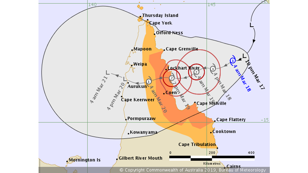
Warning zone: Cape Grenville to Cape Flattery, including Coen and Lockhart River.
Watch zone: Cape York to Cape Grenville and Cape Flattery to Cape Tribulation (including Cooktown), including adjacent inland areas.
Cancelled zones: None.
Details of Tropical Cyclone Trevor at 4:00 am AEST:
Intensity: category 1, sustained winds near the centre of 65 kilometres per hour with wind gusts to 95 kilometres per hour.
Location: within 75 kilometres of 12.4 degrees South, 146.1 degrees East , 305 kilometres east of Lockhart River and 500 kilometres north of Cairns .
Movement: west southwest at 10 kilometres per hour .
Tropical cyclone Trevor, category 1, has formed in the northern Coral Sea east of Cape York Peninsula.
Tropical cyclone Trevor is expected to move in a west-southwest direction towards the Cape York Peninsula coast. It is expected to continue intensifying, and should reach category 2 before crossing the eastern Cape York Peninsula coast later on Tuesday.
Hazards:
GALES, with gusts in excess of 90 km/h, are expected to develop between Cape Grenville and Cape Flattery on Monday night. These GALES may extend north to the Torres Strait Islands and south to Cape Tribulation, including Cooktown, on Tuesday.
DESTRUCTIVE WINDS, with gusts in excess of 125 km/h, may occur as the centre of the cyclone makes landfall on the eastern Cape York Peninsula coast later on Tuesday.
As the cyclone crosses the coast, ABNORMALLY HIGH TIDES are expected about the far north Queensland coast. Large waves are likely along the beachfront.
HEAVY RAINFALL, which may lead to flash flooding, is forecast to develop across far north Queensland over the next few days.
Recommended Action:
People between Cape Grenville and Cape Flattery, including Lockhart River and Coen, should immediately commence or continue preparations, especially securing boats and property, using available daylight hours.
People elsewhere between the Torres Strait Islands and Cape Tribulation, including Cooktown should consider what action they will need to take if the cyclone threat increases, and listen to the next advice at 8am AEST.
- Information is available from your local government.
- For cyclone preparedness and safety advice, visit Queensland's Disaster Management Services website (www.disaster.qld.gov.au).
- For emergency assistance call the Queensland State Emergency Service (SES) on 132 500 (for assistance with storm damage, rising flood water, fallen trees on buildings or roof damage).